Difference between revisions of "M700 Survey Scanner"
From Kerbal Space Program Wiki
m (*use template to automatically add category;) |
(New section: Scanning altitude) |
||
| Line 8: | Line 8: | ||
|This orbital survey scanner uses a combination of advanced sensor technology and witchcraft to provide information on a planet or moons natural resources. These images can be viewed either in flight, or in relative safety and comfort back at the KSC. Be sure to bring an antenna capable of transmitting the information back, and sufficient power. | |This orbital survey scanner uses a combination of advanced sensor technology and witchcraft to provide information on a planet or moons natural resources. These images can be viewed either in flight, or in relative safety and comfort back at the KSC. Be sure to bring an antenna capable of transmitting the information back, and sufficient power. | ||
}} | }} | ||
| + | |||
| + | == Scanning altitude == | ||
| + | |||
| + | The scanner has a minimum and maximum scanning altitude based on the radius of the body it is scanning, clamped to a lowest minimum altitude of 25 km, and highest maximum altitude of 1.5 Mm. | ||
| + | |||
| + | {| class="wikitable" | ||
| + | |- <!-- sort doesn't work with rowspan --> | ||
| + | ! rowspan="2" | Celestial body | ||
| + | ! rowspan="2" | Radius | ||
| + | ! colspan="2" | Altitude | ||
| + | |- | ||
| + | ! Min. | ||
| + | ! Max. | ||
| + | {{{{NAMESPACE}}:{{PAGENAME}}/Altitude row|Kerbol}} | ||
| + | {{{{NAMESPACE}}:{{PAGENAME}}/Altitude row|Moho}} | ||
| + | {{{{NAMESPACE}}:{{PAGENAME}}/Altitude row|Eve}} | ||
| + | {{{{NAMESPACE}}:{{PAGENAME}}/Altitude row|Gilly}} | ||
| + | {{{{NAMESPACE}}:{{PAGENAME}}/Altitude row|Kerbin}} | ||
| + | {{{{NAMESPACE}}:{{PAGENAME}}/Altitude row|Mun}} | ||
| + | {{{{NAMESPACE}}:{{PAGENAME}}/Altitude row|Minmus}} | ||
| + | {{{{NAMESPACE}}:{{PAGENAME}}/Altitude row|Duna}} | ||
| + | {{{{NAMESPACE}}:{{PAGENAME}}/Altitude row|Ike}} | ||
| + | {{{{NAMESPACE}}:{{PAGENAME}}/Altitude row|Dres}} | ||
| + | {{{{NAMESPACE}}:{{PAGENAME}}/Altitude row|Jool}} | ||
| + | {{{{NAMESPACE}}:{{PAGENAME}}/Altitude row|Laythe}} | ||
| + | {{{{NAMESPACE}}:{{PAGENAME}}/Altitude row|Vall}} | ||
| + | {{{{NAMESPACE}}:{{PAGENAME}}/Altitude row|Tylo}} | ||
| + | {{{{NAMESPACE}}:{{PAGENAME}}/Altitude row|Bop}} | ||
| + | {{{{NAMESPACE}}:{{PAGENAME}}/Altitude row|Pol}} | ||
| + | {{{{NAMESPACE}}:{{PAGENAME}}/Altitude row|Eeloo}} | ||
| + | |} | ||
== Changes == | == Changes == | ||
Revision as of 11:16, 14 May 2015
| M700 Survey Scanner | ||
| Scanner by Experimental Engineering Group | ||
| Radial size | Small | |
| Cost | (total) | 1 500.00 |
| Mass | (total) | 0.20 t |
| Drag | 0.2 | |
| Max. Temp. | 2000 K | |
| Volume | ? | |
| Impact Tolerance | 7 m/s | |
| Research | | |
| Unlock cost | 4 500 | |
| Since version | 1.0 | |
| Part configuration | SurveyScanner.cfg | |
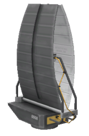
The M700 Survey Scanner is a part introduced in version 1.0.
Product description
| “ | This orbital survey scanner uses a combination of advanced sensor technology and witchcraft to provide information on a planet or moons natural resources. These images can be viewed either in flight, or in relative safety and comfort back at the KSC. Be sure to bring an antenna capable of transmitting the information back, and sufficient power. | ” |
Scanning altitude
The scanner has a minimum and maximum scanning altitude based on the radius of the body it is scanning, clamped to a lowest minimum altitude of 25 km, and highest maximum altitude of 1.5 Mm.
| Celestial body | Radius | Altitude | |
|---|---|---|---|
| Min. | Max. | ||
| Kerbol | 261.6 Mm | N/A | N/A |
| Moho | 250 km | 25 km | 1.25 Mm |
| Eve | 700 km | 70 km | 1.5 Mm |
| Gilly | 13 km | 25 km | 65 km |
| Kerbin | 600 km | 60 km | 1.5 Mm |
| Mun | 200 km | 25 km | 1000 km |
| Minmus | 60 km | 25 km | 300 km |
| Duna | 320 km | 32 km | 1.5 Mm |
| Ike | 130 km | 25 km | 650 km |
| Dres | 138 km | 25 km | 690 km |
| Jool | 6 Mm | 600 km | 1.5 Mm |
| Laythe | 500 km | 50 km | 1.5 Mm |
| Vall | 300 km | 30 km | 1.5 Mm |
| Tylo | 600 km | 60 km | 1.5 Mm |
| Bop | 65 km | 25 km | 325 km |
| Pol | 44 km | 25 km | 220 km |
| Eeloo | 210 km | 25 km | 1.05 Mm |
Changes
- Initial release
