Difference between revisions of "Woomerang Launch Site"
From Kerbal Space Program Wiki
UmbralRaptor (talk | contribs) |
UmbralRaptor (talk | contribs) (More building detail) |
||
| Line 5: | Line 5: | ||
=== Buildings === | === Buildings === | ||
| − | The site consists solely of a [[launch pad]], which counts as its own biome. | + | The site consists solely of a [[launch pad]]/ramp, which counts as its own biome (separate from the KSC launch pad). The nearest tracking station is Nye Island, some 475 km away. |
=== Trivia === | === Trivia === | ||
Revision as of 01:27, 28 March 2018
| Woomerang Launch Site | ||
| Location | | |
| | ||
| Coordinates Map |
45° 17′ 24″ N | |
| 136° 6′ 36″ E | ||
| Altitude | 739 m | |
| Since version | 1.4.1 | |
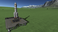
The Woomerang launch site is a new site in the Making History expansion, and perhaps the 4th spaceport on Kerbin. It is situated at a high latitude (approximately 45 degrees north) peninsula, to provide additional variety and challenge for missions. The site is currently extremely austere, consisting solely of a launch pad. The surrounding environment is moderately sloped, and surrounded by mountains (and more distantly ocean).
Contents
Buildings
The site consists solely of a launch pad/ramp, which counts as its own biome (separate from the KSC launch pad). The nearest tracking station is Nye Island, some 475 km away.
Trivia
Woomerang is likely a reference to the [Woomera Range Complex]
