File:Minmus Topo mercator 400x400.png
From Kerbal Space Program Wiki
Minmus_Topo_mercator_400x400.png (400 × 420 pixels, file size: 272 KB, MIME type: image/png)
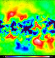
A topographic map of Minmus made with the "ISA MapSat - Satellite mapping module and map generation tool v3.1.0" plugin developed by the "Innsewerants Space Agency".
File history
Click on a date/time to view the file as it appeared at that time.
| Date/Time | Thumbnail | Dimensions | User | Comment | |
|---|---|---|---|---|---|
| current | 21:04, 25 August 2012 |  | 400 × 420 (272 KB) | Arpanet (talk | contribs) | A topographic map of Minmus made with the "ISA MapSat - Satellite mapping module and map generation tool v3.1.0" plugin developed by the "Innsewerants Space Agency". |
- You cannot overwrite this file.
