Difference between revisions of "Old Airfield"
m (XZise moved page Insular Airfield to Old Airfield: official name) |
(Old Airfield is the new airfield; +aliases) |
||
| Line 9: | Line 9: | ||
{{spoiler}} | {{spoiler}} | ||
| − | ''' | + | '''Old Airfield''' (a.k.a. “Insular Airfield” or “Island Airport” before official naming) is an “anomaly” or easter egg consisting of a landing strip running east-west and, south of it, a control tower and two open hangars. Flanking the buildings are also six rectangular sections of various dimensions outlined by low walls. The airfield appears abandoned and in disrepair. |
The landing strip is approximately 1.25 km long, perfectly level at ~133 m above sea level, and appears to be dirt. The east and west ends of the strip drop off sharply and there are steep hills running parallel on the north and south sides, making landings more dangerous than at [[Kerbal Space Center]]'s [[Runway]]. Like at its mainland counterpart, wheeled vehicles parked on the landing strip without brakes engaged will slowly roll toward the length midpoint. Unlike the Runway, the landing strip is not illuminated; the only light is a beacon on top of the control tower. | The landing strip is approximately 1.25 km long, perfectly level at ~133 m above sea level, and appears to be dirt. The east and west ends of the strip drop off sharply and there are steep hills running parallel on the north and south sides, making landings more dangerous than at [[Kerbal Space Center]]'s [[Runway]]. Like at its mainland counterpart, wheeled vehicles parked on the landing strip without brakes engaged will slowly roll toward the length midpoint. Unlike the Runway, the landing strip is not illuminated; the only light is a beacon on top of the control tower. | ||
| Line 35: | Line 35: | ||
== History == | == History == | ||
[[File:Insular Airfield from plane pre22.png|thumb|Old look prior to 0.22]] | [[File:Insular Airfield from plane pre22.png|thumb|Old look prior to 0.22]] | ||
| − | In {{version|0.18}}, the ground had a rock-sand texture and was elevated above the beach terrain around it. There were three hangars. The tower was octagonal and a completely closed structure. All buildings were south of the landing strip.<ref>[https://www.youtube.com/8FETG6XbiGY?t=4m40s Earliest known YouTube video of landing at | + | In {{version|0.18}}, the ground had a rock-sand texture and was elevated above the beach terrain around it. There were three hangars. The tower was octagonal and a completely closed structure. All buildings were south of the landing strip.<ref>[https://www.youtube.com/8FETG6XbiGY?t=4m40s Earliest known YouTube video of landing at Old Airfield]</ref> |
| − | Prior to the redesign in {{version|0.22}} the landing strip had been changed to a grass-like texture and was situated on grassy terrain, which some found hard to distinguish for landing. The buildings were all moved to the north side of the landing strip.<ref>[https://www.youtube.com/qTQL5SpRXNs?t=3m YouTube video of | + | Prior to the redesign in {{version|0.22}} the landing strip had been changed to a grass-like texture and was situated on grassy terrain, which some found hard to distinguish for landing. The buildings were all moved to the north side of the landing strip.<ref>[https://www.youtube.com/qTQL5SpRXNs?t=3m YouTube video of Old Airfield between v0.18 and v0.22]</ref> |
==References== | ==References== | ||
Revision as of 00:53, 11 July 2014
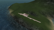
Old Airfield (a.k.a. “Insular Airfield” or “Island Airport” before official naming) is an “anomaly” or easter egg consisting of a landing strip running east-west and, south of it, a control tower and two open hangars. Flanking the buildings are also six rectangular sections of various dimensions outlined by low walls. The airfield appears abandoned and in disrepair.
The landing strip is approximately 1.25 km long, perfectly level at ~133 m above sea level, and appears to be dirt. The east and west ends of the strip drop off sharply and there are steep hills running parallel on the north and south sides, making landings more dangerous than at Kerbal Space Center's Runway. Like at its mainland counterpart, wheeled vehicles parked on the landing strip without brakes engaged will slowly roll toward the length midpoint. Unlike the Runway, the landing strip is not illuminated; the only light is a beacon on top of the control tower.
The tower is particularly ruinous with segments of the façade fallen down and ivy growing inside. It is possible to get a Kerbal to the top via an outdoor staircase accessible from the north side of the tower. Attempting to place a flag inside results in it appearing on top of the tower.
The hangars are open on their north and south ends. Their floors look eroded and with dirt washed in.
Contents
Gallery
In the far right hangar, there are some old rusty parts lying around. These are the old models of the Command Pod Mk1, FL-T500 Fuel Tank and the LV-T30 Liquid Fuel Engine. Note that the command pod's scale is incorrect; it now appears to have a large radial size on the bottom, although it had a small one while still available as a part.
Location
The airfield is located on the north side of the largest and northernmost of the string of islands ~32 km east-southeast of KSC.
History
In version 0.18, the ground had a rock-sand texture and was elevated above the beach terrain around it. There were three hangars. The tower was octagonal and a completely closed structure. All buildings were south of the landing strip.[1]
Prior to the redesign in version 0.22 the landing strip had been changed to a grass-like texture and was situated on grassy terrain, which some found hard to distinguish for landing. The buildings were all moved to the north side of the landing strip.[2]
References
- ↑ Earliest known YouTube video of landing at Old Airfield
- ↑ YouTube video of Old Airfield between v0.18 and v0.22


