Difference between revisions of "Duna"
(Moved in-game description up top; is most official text on Duna) |
m (Reverted edits by Kerbin fellow (talk) to last revision by KAL2000) |
||
| (154 intermediate revisions by 68 users not shown) | |||
| Line 1: | Line 1: | ||
{{Infobox/Body}} | {{Infobox/Body}} | ||
| − | '''Duna''' is the fourth planet | + | '''Duna''' is the fourth planet in the Kerbol system and ranks as the fourth largest. Known as the Kerbal Space Program's counterpart to Mars, it features a red-brown surface and polar ice caps akin to those found on Kerbin. Duna hosts one prominent natural satellite, the tidally-locked [[moon]] called [[Ike]]. |
| − | + | Duna orbits Kerbol with an inclination nearly identical to that of Kerbin, making it one of the easiest planets to encounter. Achieving a round trip from Kerbin to orbit around Duna and back requires approximately 1700 m/s of delta-v from Low Kerbin Orbit (LKO), assuming proper aerobraking and a ballistic insertion burn from 100 km. Different orientations of Kerbin and Duna may necessitate higher delta-v budgets for the journey. | |
| − | + | A [[Tutorial:How to get to Duna|tutorial to get to Duna]] is available at the link. | |
| + | == In-game description == | ||
| + | |||
| + | '''KSP 1:''' | ||
{{Quote | {{Quote | ||
| + | |Also known as the red dot that you can see if you squint at it really hard, Duna has long been a wonder to Kerbalkind. The planet has been held in much awe, due to its striking red color and stark contrast to the color green. | ||
| + | |[[Kerbal Astronomical Society]]}} | ||
| − | | | + | '''KSP 2:''' |
| + | {{Quote | ||
| + | |Duna, The Reddest Planet, has long been an object of study and inspiration to Kerbal scientists and artists alike! Its thin, low-pressure atmosphere allows for both aerobraking and relatively easy access to its surface. Kerbal researches and sci-fi writers often discuss the discoveries that could be waiting for them in the planet's polar ice caps or on Duna's tidally locked moon, Ike.|}} | ||
| − | | | + | == Topography == |
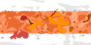
| + | [[File:Duna_heightmap_2018.png|thumb|left|A topographic map of Duna obtained with the Kittopia mod (2018)]] | ||
| + | Duna's terrain ranges in altitude from 124 to 8264 meters. Its mountain ranges are a peril to landing [[craft]], due to their steepness and the limited [[aerobraking]] that is possible in Duna's tenuous [[atmosphere]] at such altitudes. | ||
| − | + | Duna has several craters. They appear quite eroded, presumably by the wind of the (small) atmosphere. | |
| − | |||
| − | |||
| − | + | Several [[w:Lunar maria|maria]] (large regions of dark soil) are around several hundred meters altitude. Their low altitude allows for more aerobraking, and the flatness of the terrain makes them easy but boring landing locations. These may have been lakes when the planet may have had liquid on its surface in the past. | |
| − | + | Duna's surface contains 5 [[List of easter eggs#Duna|anomalous features]]. | |
| − | + | == Biomes== | |
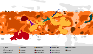
| − | + | Duna has 14 [[Biome]]s. Within the generic mix of Low-, Mid- and Highlands lie various Basins and Canyons with some scattered craters. The most dominant feature is the Midland Sea,<ref>Not a real sea. For real seas, see [[Kerbin]], [[Laythe]], [[Eve]].</ref> which spans half the Planet. The Poles also include separate Highlands and Craters. Duna also has gigantic ice caps. | |
| − | [[ | ||
| − | [[ | ||
| − | + | === Biome list === | |
| + | {{Biome list| | ||
| + | * Poles | ||
| + | * Polar Highlands | ||
| + | * Polar Craters | ||
| + | * Highlands | ||
| + | * Midlands | ||
| + | * Lowlands | ||
| + | * Craters | ||
| + | * Midland Sea | ||
| + | * Northeast Basin | ||
| + | * Southern Basin | ||
| + | * Northern Shelf | ||
| + | * Midland Canyon | ||
| + | * Eastern Canyon | ||
| + | * Western Canyon}} | ||
| − | + | [[File:DunaBiomeMap.png|thumb|none|Duna biome map (legend)]] | |
| − | === | + | == KSP2 == |
| − | |||
| − | + | === Research Orbital Boundaries === | |
| + | . | ||
{| class="wikitable" | {| class="wikitable" | ||
| − | |||
| − | |||
|- | |- | ||
| − | ! | + | ! Boundary !! Altitude |
| − | | | + | |- |
| − | |} | + | | Atmosphere || 0 - 49 999 m |
| + | |- | ||
| + | | Low Orbit || 50 000 m - 69 999 m | ||
| + | |- | ||
| + | | High Orbit || 70 000 m - 47 921 949 m | ||
| + | |} | ||
| + | |||
| + | === Surface Research Locations === | ||
| + | Surface research locations on Duna include: | ||
| − | + | * Highlands | |
| + | * Lowlands | ||
| + | * Midlands | ||
| + | * Monument | ||
| + | * Polar Deserts | ||
| + | * North Pole | ||
| + | * South Pole | ||
| − | + | === Maps === | |
| + | ==== Biomes ==== | ||
| + | [[File:duna_region_ui.jpg|thumb|none|Duna biome map with legend (as of v0.2.1.0 (from Orbital Survay mod))]] | ||
| + | [https://i.imgur.com/gCZ83i6.jpeg Duna biome map (Imgur)] | ||
| − | [[File: | + | ==== Visual map ==== |
| + | [[File:duna_visual.png|thumb|none|Duna visual map (as of v0.2.1.0)]] | ||
| + | [https://i.imgur.com/45o0hZ1.png Duna visual map (Imgur)] | ||
| − | == | + | == Atmosphere == |
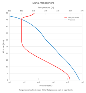
| + | [[File:Duna_Atmosphere_T&P.png|thumbnail|left|Temperature and pressure of Duna's atmosphere as a function of altitude.]] | ||
| − | + | Duna has a thin, cool [[atmosphere]] with a mass of approximately 3.0×10<sup>15</sup> kilograms, a datum level pressure of 6.755 kilopascals (0.067 atmosphere), and a depth of 50,000 meters. Compared to the atmosphere of [[Kerbin]], Duna's atmosphere has 1/15<sup>th</sup> the mass, 1/15<sup>th</sup> the surface pressure, and 1/9<sup>th</sup> the surface density. The datum level pressure on Duna is equivalent to that at an altitude of 14,975 m on Kerbin. The pressure at the top of Duna's highest mountain peak is only 2.4 kPa. | |
| − | + | The average [[w:Molecular_mass|molecular weight]] of Duna air is 42 g/mol, and its [[w:Heat_capacity_ratio|adiabatic index]] is 1.20. Although the composition of Duna's atmosphere is unknown, these values suggest that it may consist largely of [[w:Carbon_dioxide|carbon dioxide]]. | |
| − | + | Like all other atmospheres in the game, Duna's atmosphere fades exponentially as altitude increases. The [[w:Scale_height|scale height]] varies with altitude, which is a change from pre-1.0 [[Version_history|versions]] of the game. The pressure-altitude profile is globally constant and independent of temperature. The following table gives the atmospheric pressure at various altitudes above the datum level. | |
| − | |||
{| class="wikitable" | {| class="wikitable" | ||
|- | |- | ||
| − | ! Altitude (m) !! | + | ! Altitude (m) !! Pressure (Pa) !! Pressure (atm) |
|- | |- | ||
| − | | | + | | 0 || 6 755 || 0.067 |
|- | |- | ||
| − | | | + | | 2 500 || 5 136 || 0.051 |
|- | |- | ||
| − | | | + | | 5 000 || 3 774 || 0.037 |
|- | |- | ||
| − | | | + | | 7 500 || 2 663 || 0.026 |
|- | |- | ||
| − | | | + | | 10 000 || 1 797 || 0.018 |
|- | |- | ||
| − | | | + | | 15 000 || 716.9 || 0.007 |
|- | |- | ||
| − | | | + | | 20 000 || 241.0 || 0.002 |
|- | |- | ||
| − | | | + | | 25 000 || 91.73 || 0.001 |
|- | |- | ||
| − | | | + | | 30 000 || 32.90 || 0.000 |
|- | |- | ||
| − | | | + | | 40 000 || 4.918 || 0.000 |
| + | |- | ||
| + | | 50 000 || 0 || 0.000 | ||
|} | |} | ||
| − | + | The surface of Duna is cold, with a globally averaged datum level temperature of approximately -23 °C. Air temperatures decrease with increasing altitude to an altitude of 30 km. Between the altitudes of 30-45 km lies an isothermal layer, having a temperature of -123 °C. | |
| − | + | Air temperatures vary with latitude and time of day. At the equator, datum level temperatures vary between a nighttime low of -20 °C and a daytime high of -2 °C. At the poles, the temperature varies between -90 °C and -85 °C. Since Duna has no axial tilt, there are no seasonal temperature variations. | |
| − | |||
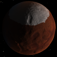
| − | + | [[File:Duna north pole.png|thumb|right|200px|Duna's north pole]] | |
| − | + | Duna's atmosphere appears to have a reddish or brownish color, both from the surface and from space. The atmosphere has this color even over the poles, where the surface is white. | |
| − | For a [[w:semi- | + | === Atmospheric flight === |
| + | The thickness of Duna's atmosphere makes it suitable for [[aerobraking|aerocapture]] from a high-speed interplanetary intercept. The periapsis altitude required for a successful aerocapture depends on the spacecraft's drag characteristics, its approach velocity, and the desired apoapsis of the resulting orbit. The most effective periapsis for aerocapture is best determined experimentally; however, for a Hohmann transfer originating from Kerbin, it appears that the target range lies between 10 km and 20 km. | ||
| + | |||
| + | Although [[parachute]]s will deploy on Duna, the atmosphere is so thin that they are usually unable to slow a craft to a safe landing velocity. They should be assisted with engines, and are best used as drouge chutes. Parachute performance can be particularly troubling when attempting to land in highland areas. Attaining the same vehicle descent rate on Duna that a vehicle would have on Kerbin requires about 2.5 times the parachute area. | ||
| + | |||
| + | Below 5 km Duna's atmosphere is thick enough to allow wings to generate enough lift for aerodynamic flight. Jet engines don't work for want of oxygen, but other propulsion methods work well. Performing a horizontal landing with a plane is also possible. | ||
| + | |||
| + | An ascent to low Duna orbit from the surface typically requires around 1400 m/s in Δv to reach a 55 km altitude traveling at roughly 900 m/s. | ||
| + | |||
| + | == Orbital statistics == | ||
| + | The [[synchronous orbit]] of Duna is at an altitude of {{OrbitAltitude|b=Duna|f=k}} above Duna. The speed of the satellite is {{OrbitVelocity|b=Duna}} and it has an orbital period resonating with 1 Duna day (18.2 hours or 65517.859375 seconds). However, this is the same altitude at which Ike orbits, so unless a ship's orbit is perfectly precise, it will eventually be captured and crash into Ike. | ||
| + | |||
| + | For a [[w:semi-synchronous orbit|semi-synchronous orbit]] of ½ Duna day (9.1 hours or 32758.9295 seconds) an orbit of | ||
{{OrbitAltitude|b=Duna|f=k|pf=1/2}} above Duna is needed with a velocity of {{OrbitVelocity|b=Duna|pf=1/2}}. | {{OrbitAltitude|b=Duna|f=k|pf=1/2}} above Duna is needed with a velocity of {{OrbitVelocity|b=Duna|pf=1/2}}. | ||
== Observation of Ike == | == Observation of Ike == | ||
| − | + | {{gif image|Ikes_libration.gif|thumb|An animation of an orbit viewed from Duna|width=304|float=left|additional css=margin-right:1em;margin-bottom:1em}} | |
| − | Ike's orbit keeps it directly above a short range of | + | Ike's orbit keeps it directly above a short range of Dunaian longitudes. The average Duna longitude that Ike tends to stay directly above (at the [[w:Zenith|Zenith]]) is 6 degrees east, but the eccentricity of Ike's orbit causes the exact longitude to oscillate between about 2 degrees and 10 degrees east and makes Ike appear to grow slightly larger and smaller to an observer on the surface of Duna. The latitude at which Ike is in the Zenith also oscillates between 0.2 degrees south and 0.2 degrees north due to Ike's orbital inclination, making Ike appear to rotate upwards and downwards as viewed from the surface, but due to the extremely small orbital inclination, this effect is nearly imperceptible. These phenomena together are known as [[w:libration|libration]]. The oscillation in Ike's position above the horizon allows areas from 88°W to 80°W and 92°E to 100°E on Duna to observe Ike rise and set at least partially across the horizon, as can any areas north of 89.8°N or south of 89.8°S. |
| − | == Interplanetary | + | == Interplanetary travel == |
| − | From altitude orbit around Duna, the | + | From a 60 km altitude orbit around Duna, the requirements for attaining an intercept trajectory of other celestials are: |
{| class="wikitable" | {| class="wikitable" | ||
!Body | !Body | ||
| − | ! | + | !Delta-V<ref>[http://www.dcl.hpi.uni-potsdam.de/home/feinbube/web/stealth/KSPDeltaVMap/ KSP Delta V Planner]</ref> |
| + | !Phase Angle<ref>[http://ksp.olex.biz/ Transfer calculator]</ref> | ||
|- | |- | ||
| [[Ike]] | | [[Ike]] | ||
| − | | | + | |align="right"| ~360 m/s |
| + | |align="right"| N/A | ||
|- | |- | ||
| [[Kerbin]] | | [[Kerbin]] | ||
| − | | | + | |align="right"| ~810 m/s |
| + | |align="right"| -75º | ||
| + | |- | ||
| + | | [[Eve]] | ||
| + | |align="right"| ~910 m/s | ||
| + | |align="right"| -169º | ||
|- | |- | ||
| [[Dres]] | | [[Dres]] | ||
| − | | | + | |align="right"| ~1200 m/s |
| + | |align="right"| 62º | ||
|- | |- | ||
| − | | [[ | + | | [[Jool]] |
| − | | | + | |align="right"| ~1610 m/s |
| + | |align="right"| 86º | ||
|- | |- | ||
| − | | [[ | + | | [[Moho]] |
| − | | | + | |align="right"| ~1650 m/s |
| + | |align="right"| -158º | ||
|- | |- | ||
| [[Eeloo]] | | [[Eeloo]] | ||
| − | | | + | |align="right"| ~1780 m/s |
| − | | | + | |align="right"| 93º |
| − | |||
| − | |||
| − | |||
|- | |- | ||
|} | |} | ||
| + | {{clear|left}} | ||
| − | == Reference | + | == Reference frames == |
{{:Duna/RefFrame}} | {{:Duna/RefFrame}} | ||
| Line 137: | Line 195: | ||
File:Parachute_Descent.png|Parachute descent down to Duna surface. | File:Parachute_Descent.png|Parachute descent down to Duna surface. | ||
File:ISA_over_Duna.png|ISA satellite in orbit over Duna being used to map the planet surface. | File:ISA_over_Duna.png|ISA satellite in orbit over Duna being used to map the planet surface. | ||
| − | File:DunaSurface.png|Duna's surface at | + | File:Kerbal Space Program Enhanced Edition 20211225182926.jpg|A small unmanned rover just saw some surface "blueberries"! |
| + | File:DunaSurface.png|Duna's surface at dawn. | ||
File:Duna_and_ike.jpg|Duna and Ike. | File:Duna_and_ike.jpg|Duna and Ike. | ||
| − | File:Duna_map_800.gif|A topographic height map of Duna made with the ISA MapSat plugin | + | File:Duna_map_800.gif|A pre-0.21 topographic height map of Duna made with the ISA MapSat plugin. |
| − | File:DoonaMap.png|A color map of Duna | + | File:DoonaMap.png|A pre-0.21 color map of Duna. |
| − | File:Duna_Sunrise.png|Duna at [http://www.youtube.com/watch?v=7czFsEpe4Ww&feature=youtu.be sunrise] | + | File:North pole of Duna.jpg|A lander on the northern pole of Duna. |
| − | File:Duna-sinkhole.png|A rover at the edge of one of the "sinkholes" | + | File:Duna_Sunrise.png|Duna at [http://www.youtube.com/watch?v=7czFsEpe4Ww&feature=youtu.be sunrise]. |
| − | + | File:Duna-sinkhole.png|A rover at the edge of one of the "sinkholes." | |
| − | |||
File:OrbitingDunaV21.1.png|A small probe orbiting Duna. | File:OrbitingDunaV21.1.png|A small probe orbiting Duna. | ||
File:Duna_Ike_Eclipse.png|Ike partially eclipsing Kerbol. Note the dimmer light and the solar panels not charging. | File:Duna_Ike_Eclipse.png|Ike partially eclipsing Kerbol. Note the dimmer light and the solar panels not charging. | ||
| − | File:Duna from ike.png| Duna seen from Ike | + | File:Duna from ike.png| Duna seen from Ike. |
| + | File:DunaSpaceTlscope.png|Duna and Ike as seen from a space telescope. | ||
| + | File:duna lander tipped over.png|The road to Duna is paved with speedbumps... | ||
| + | File:ikerise.png|...but the journey is worth the effort! | ||
| + | File:Duna rover.jpg|A rover on the surface of duna. | ||
</gallery> | </gallery> | ||
| − | == Changes == | + | == Changes KSP1 == |
| − | ; | + | ;[[1.2]] |
| + | * Added biomes | ||
| + | ;[[1.0.5]] | ||
| + | * Changed atmosphere characteristics | ||
| + | ;[[0.90]] | ||
| + | * Added biomes | ||
| + | ;[[0.21]] | ||
* Art Pass | * Art Pass | ||
| − | ; | + | ;[[0.18]] |
* Minor art pass | * Minor art pass | ||
| − | ; | + | ;[[0.17]] |
* Initial Release | * Initial Release | ||
| + | |||
| + | == Changes KSP2 == | ||
| + | ;[[KSP2 v0.2.0.0]] | ||
| + | * Added research locations | ||
== Trivia == | == Trivia == | ||
| − | * Duna's name may be either a reference to its desert landscape or a | + | [[File:EgarAndMeander.jpg|thumb|right|Egar in orbit of Meander]] |
| + | * Duna was originally called "Egar" and was in orbit of Meander, the precursor of [[Jool]]. It was described as half icy wasteland, half desert. <ref>[http://forum.kerbalspaceprogram.com/index.php?/topic/1850-a-kerbals-guide-to-our-solar-system/ Kerbol System Proposal in the forum by NovaSilisko, Aug 2011]</ref> | ||
| + | * According to former developer NovaSilisko, Duna's appearance was inspired by the theory that ice ages on Mars may have brought the ice caps much closer to its equator. - Meaning that Duna might be in a ice age. <ref>[https://forum.kerbalspaceprogram.com/topic/86696-dunas-ice-caps-are-too-big/#comment-1451461 NovaSilisko's] answer in “Duna's ice caps are too big”.</ref> | ||
| + | * Duna's name, which is the Spanish word for dune, may be either a reference to its desert landscape or a reference to the [[w:Frank Herbert|Frank Herbert]] novel ''[[w:Dune (novel)|Dune]]''. | ||
* The low-lying areas near Duna's equator make a shape resembling Europe. | * The low-lying areas near Duna's equator make a shape resembling Europe. | ||
{{SpoilerBox | {{SpoilerBox | ||
|description=Anomalous features | |description=Anomalous features | ||
|content= | |content= | ||
| + | [[File:Kerbal face.jpg|60px|right]] | ||
* On the surface of Duna, there is a large monument carved in the likeness of a [[List of easter eggs#Duna|Kerbal face]], alluding to the infamous "Face of Mars" discovered in the Cydonia Mensae region of Mars during the 1970's. | * On the surface of Duna, there is a large monument carved in the likeness of a [[List of easter eggs#Duna|Kerbal face]], alluding to the infamous "Face of Mars" discovered in the Cydonia Mensae region of Mars during the 1970's. | ||
* Buried deep under the surface, there is a small camera, similar to the design on the [[w:Curiosity (rover)|Curiosity]] rover. | * Buried deep under the surface, there is a small camera, similar to the design on the [[w:Curiosity (rover)|Curiosity]] rover. | ||
| − | * One anomalous feature on Duna is a small, pyramid-like hill emitting an SSTV signal. When decrypted, it shows a diagram-like image of three figures standing next to the hill itself, | + | * One anomalous feature on Duna is a small, pyramid-like hill emitting an SSTV signal. When decrypted, it shows a diagram-like image of three figures standing next to the hill itself, which was originally part of the developer's story but later scrapped. |
| + | * There is a stranded rover on Duna which appears similar to the NASA Spirit and Opportunity rovers. | ||
| + | * There is one randomly generated green monolith on Duna. | ||
}} | }} | ||
| + | * It may be possible to reach Duna by year 1, day 2(The next [[Time|Kerbin Day]]) by launching immediately with a delta-v of over 2 million m/s. | ||
| + | ** Duna's color map uses some details that are blended in from the old Duna color map (as well as procedural PQSLandControl coloration) however, this color map is from the old version of Duna, before its "revamp" in 0.21. The color map references features which no longer exist on Duna, and is offset by about 180 degrees longitude. | ||
| − | == Notes == | + | == References & Notes == |
<references /> | <references /> | ||
Latest revision as of 18:45, 29 September 2024
| Duna | ||
| Duna as seen from orbit. | ||
| Planet of Kerbol | ||
| Orbital Characteristics | ||
| Semi-major axis | 20 726 155 264 m [Note 1] | |
| Apoapsis | 21 783 189 163 m [Note 1] | |
| Periapsis | 19 669 121 365 m [Note 1] | |
| Orbital eccentricity | 0.051 | |
| Orbital inclination | 0.06 ° | |
| Argument of periapsis | 0 ° | |
| Longitude of the ascending node | 135.5 ° | |
| Mean anomaly | 3.14 rad (at 0s UT) | |
| Sidereal orbital period | 17 315 400 s | |
| 801 d 3 h 50 m 0.1 s | ||
| Synodic orbital period | 19 645 697.3 s | |
| Orbital velocity | 7 147 - 7 915 m/s | |
| Physical Characteristics | ||
| Equatorial radius | 320 000 m | |
| Equatorial circumference | 2 010 619 m | |
| Surface area | 1.2867964×10¹² m2 | |
| Mass | 4.5154270×10²¹ kg | |
| Standard gravitational parameter | 3.0136321×10¹¹ m3/s2 | |
| Density | 32 897.302 kg/m3 | |
| Surface gravity | 2.94 m/s2 (0.3 g) | |
| Escape velocity | 1 372.41 m/s | |
| Sidereal rotation period | 65 517.859 s | |
| 3 d 0 h 11 m 57.9 s | ||
| Solar day | 65 766.707 s | |
| 3 d 0 h 16 m 6.7 s | ||
| Sidereal rotational velocity | 30.688 m/s | |
| Synchronous orbit | 2 880.00 km | |
| Sphere of influence | 47 921 949 m [Note 1] | |
| Atmospheric Characteristics | ||
| Atmosphere present | Yes | |
| Atmospheric pressure | 6.75500 kPa | |
| 0.066667 atm | ||
| Atmospheric height | 50 000 m | |
| 6.7×10⁻⁸ atm | ||
| Temperaturemin | -123.15 °C 150 K | |
| Temperaturemax | -40.15 °C 233 K | |
| Oxygen present | No | |
| Scientific multiplier | ||
| Surface | 8 | |
| Splashed | N/A | |
| Lower atmosphere | 5 | |
| Upper atmosphere | 5 | |
| Near space | 7 | |
| Outer space | 5 | |
| Recovery | 5 | |
|
| ||
Duna is the fourth planet in the Kerbol system and ranks as the fourth largest. Known as the Kerbal Space Program's counterpart to Mars, it features a red-brown surface and polar ice caps akin to those found on Kerbin. Duna hosts one prominent natural satellite, the tidally-locked moon called Ike.
Duna orbits Kerbol with an inclination nearly identical to that of Kerbin, making it one of the easiest planets to encounter. Achieving a round trip from Kerbin to orbit around Duna and back requires approximately 1700 m/s of delta-v from Low Kerbin Orbit (LKO), assuming proper aerobraking and a ballistic insertion burn from 100 km. Different orientations of Kerbin and Duna may necessitate higher delta-v budgets for the journey.
A tutorial to get to Duna is available at the link.
Contents
In-game description
KSP 1:
| “ | Also known as the red dot that you can see if you squint at it really hard, Duna has long been a wonder to Kerbalkind. The planet has been held in much awe, due to its striking red color and stark contrast to the color green. | ” |
KSP 2:
| “ | Duna, The Reddest Planet, has long been an object of study and inspiration to Kerbal scientists and artists alike! Its thin, low-pressure atmosphere allows for both aerobraking and relatively easy access to its surface. Kerbal researches and sci-fi writers often discuss the discoveries that could be waiting for them in the planet's polar ice caps or on Duna's tidally locked moon, Ike. | ” |
Topography
Duna's terrain ranges in altitude from 124 to 8264 meters. Its mountain ranges are a peril to landing craft, due to their steepness and the limited aerobraking that is possible in Duna's tenuous atmosphere at such altitudes.
Duna has several craters. They appear quite eroded, presumably by the wind of the (small) atmosphere.
Several maria (large regions of dark soil) are around several hundred meters altitude. Their low altitude allows for more aerobraking, and the flatness of the terrain makes them easy but boring landing locations. These may have been lakes when the planet may have had liquid on its surface in the past.
Duna's surface contains 5 anomalous features.
Biomes
Duna has 14 Biomes. Within the generic mix of Low-, Mid- and Highlands lie various Basins and Canyons with some scattered craters. The most dominant feature is the Midland Sea,[1] which spans half the Planet. The Poles also include separate Highlands and Craters. Duna also has gigantic ice caps.
Biome list
|
KSP2
Research Orbital Boundaries
.
| Boundary | Altitude |
|---|---|
| Atmosphere | 0 - 49 999 m |
| Low Orbit | 50 000 m - 69 999 m |
| High Orbit | 70 000 m - 47 921 949 m |
Surface Research Locations
Surface research locations on Duna include:
- Highlands
- Lowlands
- Midlands
- Monument
- Polar Deserts
- North Pole
- South Pole
Maps
Biomes
Visual map
Atmosphere
Duna has a thin, cool atmosphere with a mass of approximately 3.0×10¹⁵ kilograms, a datum level pressure of 6.755 kilopascals (0.067 atmosphere), and a depth of 50,000 meters. Compared to the atmosphere of Kerbin, Duna's atmosphere has 1/15th the mass, 1/15th the surface pressure, and 1/9th the surface density. The datum level pressure on Duna is equivalent to that at an altitude of 14,975 m on Kerbin. The pressure at the top of Duna's highest mountain peak is only 2.4 kPa.
The average molecular weight of Duna air is 42 g/mol, and its adiabatic index is 1.20. Although the composition of Duna's atmosphere is unknown, these values suggest that it may consist largely of carbon dioxide.
Like all other atmospheres in the game, Duna's atmosphere fades exponentially as altitude increases. The scale height varies with altitude, which is a change from pre-1.0 versions of the game. The pressure-altitude profile is globally constant and independent of temperature. The following table gives the atmospheric pressure at various altitudes above the datum level.
| Altitude (m) | Pressure (Pa) | Pressure (atm) |
|---|---|---|
| 0 | 6 755 | 0.067 |
| 2 500 | 5 136 | 0.051 |
| 5 000 | 3 774 | 0.037 |
| 7 500 | 2 663 | 0.026 |
| 10 000 | 1 797 | 0.018 |
| 15 000 | 716.9 | 0.007 |
| 20 000 | 241.0 | 0.002 |
| 25 000 | 91.73 | 0.001 |
| 30 000 | 32.90 | 0.000 |
| 40 000 | 4.918 | 0.000 |
| 50 000 | 0 | 0.000 |
The surface of Duna is cold, with a globally averaged datum level temperature of approximately -23 °C. Air temperatures decrease with increasing altitude to an altitude of 30 km. Between the altitudes of 30-45 km lies an isothermal layer, having a temperature of -123 °C.
Air temperatures vary with latitude and time of day. At the equator, datum level temperatures vary between a nighttime low of -20 °C and a daytime high of -2 °C. At the poles, the temperature varies between -90 °C and -85 °C. Since Duna has no axial tilt, there are no seasonal temperature variations.
Duna's atmosphere appears to have a reddish or brownish color, both from the surface and from space. The atmosphere has this color even over the poles, where the surface is white.
Atmospheric flight
The thickness of Duna's atmosphere makes it suitable for aerocapture from a high-speed interplanetary intercept. The periapsis altitude required for a successful aerocapture depends on the spacecraft's drag characteristics, its approach velocity, and the desired apoapsis of the resulting orbit. The most effective periapsis for aerocapture is best determined experimentally; however, for a Hohmann transfer originating from Kerbin, it appears that the target range lies between 10 km and 20 km.
Although parachutes will deploy on Duna, the atmosphere is so thin that they are usually unable to slow a craft to a safe landing velocity. They should be assisted with engines, and are best used as drouge chutes. Parachute performance can be particularly troubling when attempting to land in highland areas. Attaining the same vehicle descent rate on Duna that a vehicle would have on Kerbin requires about 2.5 times the parachute area.
Below 5 km Duna's atmosphere is thick enough to allow wings to generate enough lift for aerodynamic flight. Jet engines don't work for want of oxygen, but other propulsion methods work well. Performing a horizontal landing with a plane is also possible.
An ascent to low Duna orbit from the surface typically requires around 1400 m/s in Δv to reach a 55 km altitude traveling at roughly 900 m/s.
Orbital statistics
The synchronous orbit of Duna is at an altitude of 2 880.00 km above Duna. The speed of the satellite is 306.88 m/s and it has an orbital period resonating with 1 Duna day (18.2 hours or 65517.859375 seconds). However, this is the same altitude at which Ike orbits, so unless a ship's orbit is perfectly precise, it will eventually be captured and crash into Ike.
For a semi-synchronous orbit of ½ Duna day (9.1 hours or 32758.9295 seconds) an orbit of 1 695.87 km above Duna is needed with a velocity of 386.65 m/s.
Observation of Ike
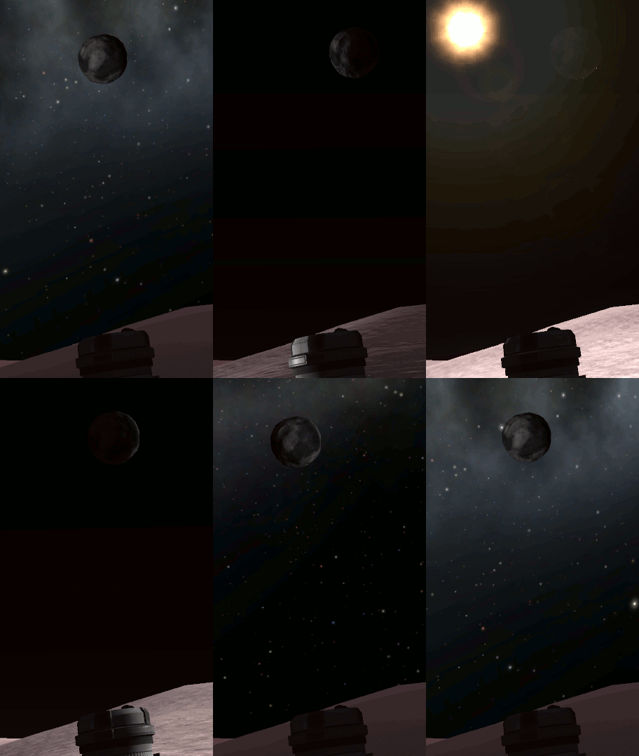
Ike's orbit keeps it directly above a short range of Dunaian longitudes. The average Duna longitude that Ike tends to stay directly above (at the Zenith) is 6 degrees east, but the eccentricity of Ike's orbit causes the exact longitude to oscillate between about 2 degrees and 10 degrees east and makes Ike appear to grow slightly larger and smaller to an observer on the surface of Duna. The latitude at which Ike is in the Zenith also oscillates between 0.2 degrees south and 0.2 degrees north due to Ike's orbital inclination, making Ike appear to rotate upwards and downwards as viewed from the surface, but due to the extremely small orbital inclination, this effect is nearly imperceptible. These phenomena together are known as libration. The oscillation in Ike's position above the horizon allows areas from 88°W to 80°W and 92°E to 100°E on Duna to observe Ike rise and set at least partially across the horizon, as can any areas north of 89.8°N or south of 89.8°S.
Interplanetary travel
From a 60 km altitude orbit around Duna, the requirements for attaining an intercept trajectory of other celestials are:
| Body | Delta-V[2] | Phase Angle[3] |
|---|---|---|
| Ike | ~360 m/s | N/A |
| Kerbin | ~810 m/s | -75º |
| Eve | ~910 m/s | -169º |
| Dres | ~1200 m/s | 62º |
| Jool | ~1610 m/s | 86º |
| Moho | ~1650 m/s | -158º |
| Eeloo | ~1780 m/s | 93º |
Reference frames
| Time warp | Minimum Altitude |
|---|---|
| 1× | Any |
| 5× | 50 000 m (above the atmosphere) |
| 10× | 50 000 m (above the atmosphere) |
| 50× | 60 000 m |
| 100× | 100 000 m |
| 1 000× | 300 000 m |
| 10 000× | 600 000 m |
| 100 000× | 800 000 m |
Gallery
Duna at sunrise.
Changes KSP1
- Added biomes
- Changed atmosphere characteristics
- Added biomes
- Art Pass
- Minor art pass
- Initial Release
Changes KSP2
- Added research locations
Trivia
- Duna was originally called "Egar" and was in orbit of Meander, the precursor of Jool. It was described as half icy wasteland, half desert. [4]
- According to former developer NovaSilisko, Duna's appearance was inspired by the theory that ice ages on Mars may have brought the ice caps much closer to its equator. - Meaning that Duna might be in a ice age. [5]
- Duna's name, which is the Spanish word for dune, may be either a reference to its desert landscape or a reference to the Frank Herbert novel Dune.
- The low-lying areas near Duna's equator make a shape resembling Europe.
- On the surface of Duna, there is a large monument carved in the likeness of a Kerbal face, alluding to the infamous "Face of Mars" discovered in the Cydonia Mensae region of Mars during the 1970's.
- Buried deep under the surface, there is a small camera, similar to the design on the Curiosity rover.
- One anomalous feature on Duna is a small, pyramid-like hill emitting an SSTV signal. When decrypted, it shows a diagram-like image of three figures standing next to the hill itself, which was originally part of the developer's story but later scrapped.
- There is a stranded rover on Duna which appears similar to the NASA Spirit and Opportunity rovers.
- There is one randomly generated green monolith on Duna.
- Duna's color map uses some details that are blended in from the old Duna color map (as well as procedural PQSLandControl coloration) however, this color map is from the old version of Duna, before its "revamp" in 0.21. The color map references features which no longer exist on Duna, and is offset by about 180 degrees longitude.
References & Notes
- ↑ Not a real sea. For real seas, see Kerbin, Laythe, Eve.
- ↑ KSP Delta V Planner
- ↑ Transfer calculator
- ↑ Kerbol System Proposal in the forum by NovaSilisko, Aug 2011
- ↑ NovaSilisko's answer in “Duna's ice caps are too big”.


